AOTEAROA NEW ZEALAND
Aotearoa New Zealand was the first country in the world to adopt breaker protection directly in regulatory instruments. New Zealand0s 2010 Coastal Policy Statement provided breakers with a legal framework at the national level. With this declaration, it granted express protection to 17 nationally significant surf breaks. This paved the way for authorities to grant protection to regionally and locally important breakers. For example, the 2009 Taranaki Regional Policy Statement recognizes 81 regionally significant breakers.
As a result, surf breaks have achieved significant legal status in the country. In addition, there are numerous cases where various proposed activities in surf break areas have been recognized and incorporated into the permiting process.
AOTEAROA NEW ZEALAND
1/
GENERAL STANDARDS FOR SURF BREAK PROTECTION
1.1. NATIONAL LEVEL STANDARDS AND DEVELOPMENTS IN MARINE-COASTAL PLANNING
In Aotearoa New Zealand, coastal management recognizes the value of surf breaks and their contribution to the natural character and landscape of the coastline. Surf breaks have high recreational, cultural and amenity value, and are a distinct sub-sector of the tourism industry.
New Zealand is one of the pioneering countries in the protection of surf breaks, since the 2010 New Zealand Coastal Policy Statement (NZCPS or Coastal Policy) granted protection to 17 surf breaks for their national significance.
The NZCPS operates under the umbrella and objectives of the Resource Management Act 1991 (RMA). The RMA establishes a comprehensive legal framework for the sustainable management of natural and environmental resources, including marine-coastal areas. Section 57 of the RMA states that New Zealand must have a mandatory coastal policy and the lead authority for its design and implementation is the Department of Conservation.
The RMA defines marine-coastal areas as the coastal zone, seabed and coastal waters, and the airspace above the water. Although the Coastal Policy does not clearly define the boundaries and jurisdiction for local authorities, it is clear that activities beyond the territorial sea are outside the scope of the Coastal Policy. It also provides guidance to local authorities for their interpretation on a case-by-case basis and for their planning processes.
In the land area, landowners may use their land as they wish, unless their use violates a rule established in a plan (district or regional) or an environmental regulation. In such cases, authorization is required. In other words, on land, everything is permitted unless it is expressly prohibited. However, in the marine realm most activities are not permitted unless expressly authorized by a rule in a regional coastal plan or other relevant legislation. Many activities may also be authorized by obtaining a resource authorization or permit, as appropriate, unless the relevant rules specifically prohibit such use.
The terrestrial component of the coastal environment, considered in the definition of 'marine-coastal area,’ is essential to address maintenance of water quality and access to surf breaks. This terrestrial component can be included in regional policy statements to help manage aspects of the coast that may affect surf breaks, e.g., in terms of access and sand mining that may alter sediment supply to the coast, or watershed runoff that may degrade water quality.
Under the Conservation Act of 1987, the Department of Conservation is charged with advocating for the conservation of natural and historic resources in general. One of its responsibilities in relation to coastal management is to prepare, monitor and evaluate the implementation of the Coastal Policy, and to approve all regional coastal plans and any changes to them. It is therefore key to actively involve the Department of Conservation in surf break protection and management initiatives.
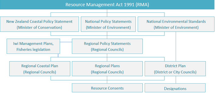
This chart shows the main components of the RMA regarding surf break management, as well as the main authorities involved.
While the Coastal Policy does not provide specific guidance on how to manage a surf break, regional policy statements, regional plans, regional coastal plans, district plans, and unitary plans must take into account the provisions of the Coastal Policy.
In accordance with the RMA, the regional coastal plans must prepare a regional coastal plan and may also prepare other regional plans that are not inconsistent with it. The purpose of these plans is to give effect to regional and national policy statements. RMA’s section 64(2) states that "a Regional Coastal Plan may be a part of a Regional Plan where it is considered appropriate for the purpose of promoting the integrated management of a Coastal Marine Area and any related area of the coastal environment." Accordingly, some regional councils have chosen to incorporate their regional coastal plan within a larger regional plan. An example is the Regional Coastal Environment Plan developed by Environment Canterbury to promote better integration of responses to concerns involving land-based activities.
Regarding surf break management, regional policy statements and regional coastal plans are important tools for wave protection. Regional plans should also take into account any relevant planning document recognized by an iwi authority (a prominent figure in Maori society), or a planning document, submitted to Council, produced by a group with some customary maritime title under the Marine and Coastal Area (Takutai Moana) Act 2011. These provide further opportunities to surf breaks relevant policies within the overall management framework.
The Coastal Policy sets out guidelines for local authorities to manage coastal ecosystems. It identifies 29 policies in relation to seven national priority policy objectives. Policy 16 calls for the protection of nationally significant surf breaks, which are the 17 listed below:
Location | Surf breaks |
|---|---|
Northland |
|
Waikato |
|
Taranaki |
|
Gisborne |
|
Coromadel |
|
Kaikora |
|
Otago |
|
In turn, policies 13 and 15 of the NZCPS indirectly protect surf breaks. Policy 13 calls for preserving the natural character of the coastal environment and protecting it from inappropriate subdivisions, uses and development. In exceptional cases, adverse effects must be completely avoided, while in other cases they are permitted to some extent—with only significant effects being prohibited. This distinction is important for determining the level of protection a zone receives. This approach includes evaluating the natural character of the regional coastal environment and ensuring that regional policy statements identify areas where conserving natural characteristics requires specific objectives, policies, and measures. Local authorities must first determine whether protection is needed, then adopt appropriate measures to achieve that protection.
Policy 15 mandates the protection of the natural features and landscapes of the coastal environment from inappropriate subdivisions, uses and development.
While Policy 16 focuses on the protection of surf breaks specifically, policies 13 and 15 allow for the protection of surf breaks as part of a broader set of natural values ("natural character or feature"). Thus, these policies contain a mandate to preserve surf breaks of regional or local importance, based on their character, either as a natural feature or by integrating an exceptional landscape. The Coastal Policy approach is a good example of a legal framework that allows for protections to be established at the national level, and progressively to also include lesser-known surf breaks of regional and local importance.
![Location of nationally significant breakers in New Zealand. Source: [Department of Conservation of New Zealand. NZCPS 2010 Guidance note, Policy 16: Surf breaks of national significance, https://www.doc.govt.nz/globalassets/documents/conservation/marine-and-coastal/coastal-management/guidance/policy-16.pdf].](https://www.protegetusolas.com/administrador/storage/uploads/2026/02/12/policy-16-sbns_olas_0_uid_698d4b40bfef0.jpg)
Location of nationally significant breakers in New Zealand. Source: [Department of Conservation of New Zealand. NZCPS 2010 Guidance note, Policy 16: Surf breaks of national significance, https://www.doc.govt.nz/globalassets/documents/conservation/marine-and-coastal/coastal-management/guidance/policy-16.pdf].
The NZCPS glossary defines the following terms:
Surf breaks are a natural formations composed of waves, currents, water levels, seabed, seabed morphology, and wind. The hydrodynamic character of the ocean (swell, currents, and water level) combines with the seafloor morphology and produces a 'surfable wave.' A surf break includes the swell window where the swell travels and also the seafloor morphology to the point where the waves dissipate and become unsurfable.
The swell or wave corridor is the offshore region of a surf break where the swell is displaced and transformed into a 'surfable wave.'
Surfable waves have a break point that breaks along the crest, so that the surfer can surf it by being propelled laterally along the crest.
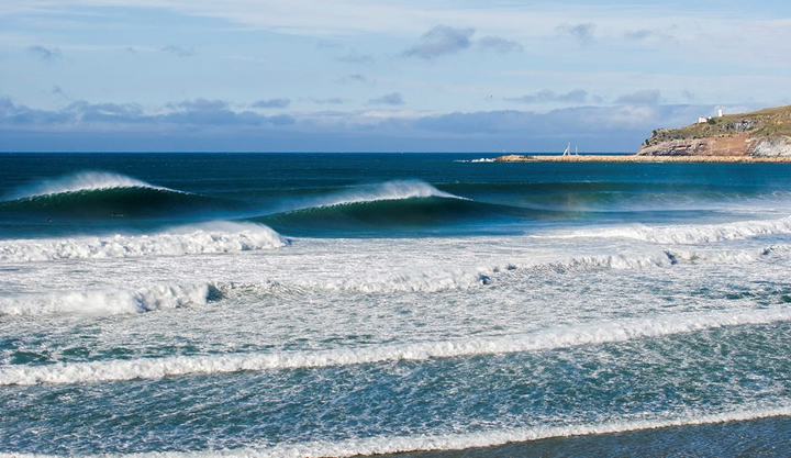
During the development of the Coastal Policy, the Board of Inquiry concluded that some of New Zealand's "surf breaks are important nationally and even internationally, attracting visitors from around the world, as well as providing a variety of surfing opportunities, including some for learning (...). Wave quality may be compromised by development of the surf corridor out to sea, and surfers' enjoyment of the breaks may be compromised by effluent, access limitations and changes to natural character."
Nevertheless, the Coastal Policy does not provide criteria for defining what constitutes a nationally significant surf break nor does it take any position on the classification of surf breaks and their importance (i.e., national, regional, or local importance). The basis for the selection of the 17 nationally important surf breaks was the New Zealand Wavetrack Surf Guide, where surf breaks were selected with a score of 10 out of 10 in a ranking defined by the author. The lack of national guidance to implement these policies has resulted in a variety of regional approaches.
The intention of the Coastal Policy Research Board was to have an inclusive approach, meaning that the list is not limited and more surf breaks may be added over time. In addition, surf breaks identified by the authorities are recognized as exceptional natural features if they meet the definition of a surf break in the NZCPS glossary. The NZCPS Board of Inquiry concluded "that there should be no criteria in the policy for the selection of new Nationally Significant Surf Breaks, given that there may be advances in the methodology for identifying and classifying surf breaks." The list of nationally significant surf breaks could be expanded at its next review (scheduled every 10 years). It is very likely that the surf breaks added to the list will have been previously recognized as being of regional importance.
1.2. PROGRESS ON SURF BREAK PROTECTION IN REGIONAL POLICIES
New Zealand is at the forefront of surf break management, as national, regional and local authorities are required to implement the Coastal Policy by incorporating surf breaks into their policies and planning processes.
As noted above, the Coastal Policy identifies and includes a list of nationally significant surf breaks, but does not set criteria for determining when a surf break should be categorized as regionally or locally significant.
Regional and local authorities have identified regionally important surf breaks in order to elevate the status of a set of surf breaks within each region and thus provide them with some degree of protection in plans and planning processes. That is, the categorization of a surf break as being of national or regional importance (or having been identified although not yet categorized) is closely linked to the level of protection proposed. At least 247 surf breaks have received some level of protection under these policies, according to an assessment completed in 2017 (Orchard, 2017a).
Date | Policy Instrument | Methodology | References |
2010 | Declaración Política Regional para Taranaki | Rompientes identificadas en Wavetrack (Morse y Brunskill, 2004) y otras nominadas para su inclusión a través de consultas con la comunidad local de surf. | TRC (2004; 2010) |
2015 | Propuesta de Plan de Recursos Naturales para la región de Wellington | Rompientes identificadas en Wavetrack (Morse y Brunskill, 2004) y otras nominadas para su inclusión a través de consultas con la comunidad local de surf. | GWRC (2015) Gunson et al. (2014); Atkin et al. (2015) |
2016 | Plan Unitario de Auckland Operativo en Parte | Rompientes identificadas en Wavetrack (Morse y Brunskill, 2004), conocimiento local del staff del consejo local y consultas con la comunidad local. | AC (2016); Coombes & Scarfe (2010); McNeil & Coombes (2012) |
2017 | Propuesta de Plan Regional para el Medio Ambiente Costero de la Bahía de Plenty | Rompientes identificadas en Wavetrack (Morse y Brunskill 2004) y otras nominadas para su inclusión mediante consultas con la comunidad local de surf. | BPRC (2017); Peryman (2011a) |
2017 | Propuesta de Plan Regional para Northland | Rompientes identificadas en Wavetrack (Morse y Brunskill, 2004) o nominadas por el panel de expertos locales. | NRC (2016b; 2017) |
2018 | Propuesta de Plan Costero para Taranaki | Inventario regional de rompientes, encuesta a la comunidad sobre los valores de las rompientes y evaluación de las rompientes con respecto a los umbrales de importancia regional. | TRC (2017; 2018); Orchard (2017c) |
Table presenting the regional policy statements and regulatory plans of New Zealand that have identified regionally significant surf breaks, and on the other hand, the methodologies used for their identification. Source: Atkin, E.; Bryan et al. (2019). Management Guidelines for Surfing Resources. Raglan, Aotearoa New Zealand: Aotearoa New Zealand Association for Surfing Research.
Methodologies for gathering local knowledge have included workshops, interviews, surveys (both face-to-face and online) and various methods of stakeholder engagement, including publicly advertised engagement opportunities.
Local knowledge has also been incorporated directly into the identification of regionally significant surf breaks. For example, even the simplest approaches in the form of "create a list" have provided experts with the opportunity to apply their judgment in determining which surf breaks to include.
1.2.1. TARANAKI
The Taranaki Regional Council was the first local authority to provide protection of surf breaks under the Resource Management Act. The 2009 Taranaki Regional Coastal Policy recognizes 81 regionally significant surf breaks. These are mapped and delineate the location of a surf break. Some of these are within a yellow shaded area identified as "coastal area of local or regional significance," but it is unclear whether the extent of the shading reflects the spatial area of the surf break.
The Taranaki Regional Coastal Policy refers to surf breaks in general terms, but does not mention them in its objectives. The importance of including the concept of 'surge corridors' has also been noted, as the Taranaki coastal marine area is actually a major surge corridor for the 81 regionally significant surf breaks identified in the policy.
In 2018, a Coastal Plan for Taranaki was proposed, which used a participatory approach to rank surf breaks according to regionally significant criteria. The results of the community survey were published and discussed as part of the plan review process.
1.2.2. AUCKLAND
Coombes and Scarfe (2010) proposed criteria for the assessment of surf breaks when formulating policy recommendations for the Auckland Regional Policy Statement (ARPS). These criteria were considered to characterize a list of regional surf breaks identified by Morse and Brunskill (2004), information from the Surfbreak Protection Society (a New Zealand-based non-profit organization), and local knowledge from the council. The criteria were not used to classify surf breaks into categories such as regionally or locally significant, but to provide information relevant to their management (Coombes and Scarfe, 2010; McNeil and Coombes, 2012). The proposed list of regionally significant surf breaks was subject to community consultation, which resulted in several modifications before being adopted within the Auckland Unitary Plan, which incorporates the Auckland Coastal Policy (AC, 2016).
Although the assessment criteria proposed by Coombes and Scarfe (2010) were not used directly to identify the level of significance, they have influenced processes and informed further research.
1.2.3. GISBORNE & BAY OF PLENTY
In 2011, regionally significant surf breaks were considered during the planning process in the Bay of Plenty and Gisborne districts (Peryman, 2011a,b ). In the Gisborne study, surveys were used to gather information from community members on the importance of 20 factors relevant to surf breaks (Coombes and Scarfe, 2010; Peryman, 2011). The Bay of Plenty study used a reduced set of 11 evaluation criteria according to a similar approach (Peryman, 2011a). The combined data from both studies were evaluated by Peryman and Orchard (2013) to identify the main value categories associated with surf breaks from the perspective of coastal communities in those regions.
In these studies, the selected surf breaks had already been nominated for their regional significance by local stakeholders, rather than having been identified through an assessment process properly designed for that purpose. The objective was to understand the values associated with regional surf breaks from a broader community perspective. In this respect, the reasoning was similar to that of Coombes and Scarfe (2010; also available at McNeil and Coombes, 2012), but it was extended beyond an expert panel assessment, to incorporate a community perspective. The values identified provided useful evidence to support the selection of criteria for more comprehensive regional assessments.
Such values include physical and mental health benefits, educational, lifestyle, spiritual, experiential, and entertainment values, cultural use and enjoyment, cultural significance of some identified sites, importance of natural features, and economic effects of commercial activities.
The Bay of Plenty Regional Council also has a Regional Coastal Policy. Specifically, its policy CE 8B ensures that subdivision, use and development are appropriate and compatible with the natural features of the coastal environment.
1.2.4. NORTHLAND
In Northland, criteria were used to identify regionally significant surf breaks, which were then included in a legal plan. The main attributes considered for assessments were, among others, rarity of surf break types, wave quality, consistency, uniqueness, nature conservation, level of use, economic value, and education.
The concept of 'regional importance' was finally derived through a weighted-sum Multi-criteria Analysis. The result was a summed score out of 60 for each surf break: it had to reach or exceed the threshold of 31 points to be categorized as a surf break of regional importance (NRC, 2016b).
1.2.5. WAIKATO
The Waikato Navigation Safety Bylaw (2003-2020) was established under the Maritime Transport Act 1994, and applies to most navigable waters within the Waikato Regional Council's jurisdiction. Its main objective is to reduce conflicts between user groups and water recreation modes. In this way, incompatible activities in surface waters, such as boat channels and surf break zones, can be separated, with a focus on safety (Waikato Regional Council, 2020).
Raglan, the country's best-known surfing destination, was regulated in a 2003 updated bylaw to protect surfers as a user group in that area. In 2006, another break zone was delineated at the entrance to Whangamatā Harbour, home to another of the country's most famous surf breaks, Whangamatā Bar. The bylaw also includes locally important surf breaks such as Manu Bay and Whale Bay. Thus, measures are established to control the use of boats in reserved areas where recreational activities such as surfing, swimming and diving are practiced. Its implementation is achieved through the mapping of the reserved zones in the bylaw and on-site signage.
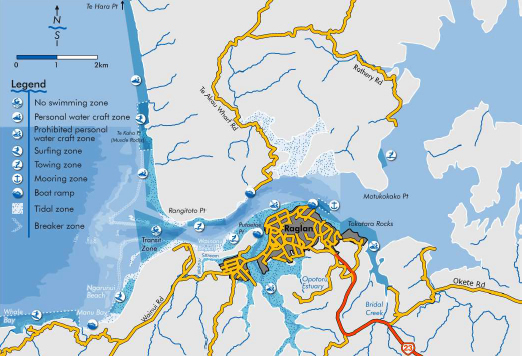
Map of Raglan with surfing areas designated as reserved areas. Source: Navigation Safety Bylaw.
1.2.6. SOUTHLAND
The 2017 Southland Regional Policy contains a chapter on the coastal environment. Meanwhile, the 2008 Ngāi Tahu ki Murihiku, Iwi Environment and Natural Resources Management Plan (Te Tangi a Tauira) is a planning document that identifies a range of activities that may affect the cultural health of the coastal environment. In 2021, Environment Southland undertook a review of its Regional Coastal Plan and has requested the identification of regionally significant surf breaks in Southland for inclusion in the plan.
The 13 surf breaks of national significance, from west to east, are Big Bay, Martins Bay, Blue Cliffs, Frenches Reef, Porridge, Beatons, Raratoka, Nicks Point, Colac Bay, Riverton Rocks, Oreti Beach, Haldane Bay, and Porpoise Bay. Each regionally significant surf break is delineated as a surf break area. Porridge and Beatons, and Martins Bay and Big Bay share surf break areas named, respectively, Pahia and Awarua. It is recommended to include these regionally significant surf breaks in the Southland Regional Coastal Plan.
More research and information is needed to conclusively determine whether Mason Bay, Saber Reef, Avalanches, 2nd Break, and 3rd Break can be considered regionally significant. In the meantime, it is recommended to at least recognize as surfing resources under the consideration of "surf breaks of local significance, or potential regionally significant surf breaks."
Environment Southland's efforts to protect its surf breaks include the following methodological components:
Identification of surf breaks
Characterization
Significance criteria (public consultation)
Delineation of surf break zones for each surf break of regional significance
Delimitation of swell or surge corridors
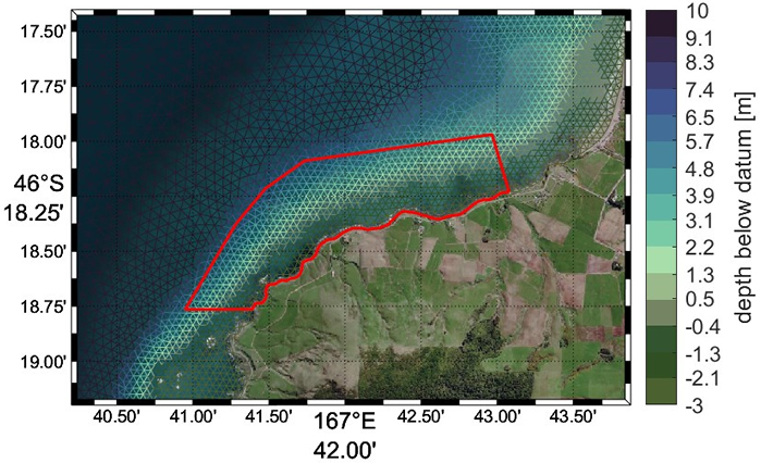
Delimitation, in red, of the surf break area for Frenches Reef. Source: Environment Southland.
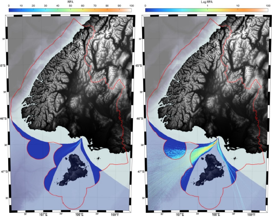
Riverton Rocks swell corridor superimposed on model topography and bathymetry. The red line is the Environment Southland jurisdictional area. The surge corridor outside the territorial sea is translucent. The graded color of the surge corridor is 'relative percent activity' (left) and is provided on a logarithmic scale (right) to visualize the full range. Source: Environmental Southland.
2/
SURF BREAKS AND ENVIRONMENTAL IMPACT ASSESSMENT
Under the Resource Management Act of 1991, any person or entity wishing to undertake an activity that may have a significant impact on the environment must apply for authorization. This includes activities such as, but is not limited to, infrastructure construction, natural resource extraction, urban development and intensive agriculture.
The environmental impact assessment (EIA) process involves submitting an environmental consent application to the appropriate local or regional authority. This application must include detailed information on the potential environmental effects of the proposed activity, as well as proposed mitigation and management measures. The EIA should include all potential impacts on the environment, an assessment of the level of potential impacts and a proposal to avoid remedy or mitigate adverse impacts.
The competent authority will review the application and conduct an EIA to determine the potential effects and risks. Consideration should also be given to the values and principles of the Treaty of Waitangi, which establishes a partnership between the New Zealand government and the Maori.
The competent authority may grant environmental consent, depending on the assessment, with or without conditions, deny consent or request additional information. If consent is granted, specific conditions may be attached to ensure mitigation of environmental impacts and ongoing monitoring of the activity.
To effectively manage surf breaks, EIA processes require that the potential and actual impacts of the activity be reflected, how it should be monitored, as well as the management procedures that can be implemented to avoid, remedy or mitigate any adverse impacts.
With regard to surf breaks, the main impacts to be prevented are those that may modify surf break characteristics, water quality and access to surf breaks. Therefore, it is essential to collect baseline data to determine the characteristics and mechanics of surfing waves. In addition, due to lack of research, many potential impacts on surf breaks are still unknown. This means that baseline monitoring is critical to determine impacts.
An EIA should ensure that effects on a surf break (actual and potential) are minor or negligible, or that any adverse effects can be avoided, remedied or mitigated before granting resource authorization.
Impacts on surf breaks have traditionally been ignored; where such impact has been recognized, it has been superficially reviewed. For example, when the Manu Bay boat ramp was built, all environmental permits were obtained and the ramp was built without any serious investigation of the impacts the ramp would have on surf breaks: technical methodologies for assessing surf breaks did not exist and were not required during the EIA process.
Several experts have pointed out that one of the keys to success in integrated coastal zone management is the identification and collection of relevant data to manage threats or to determine what elements an EIA should include for surf break protection. It is key to invest in the ongoing collection of such data so that it is readily available in the event that a surf break is threatened.
However, there is a significant list of cases where impacts on surf breaks have either been recognized and incorporated into the EIA for the resource consent application, or have been challenged in the trials of the Environment Court and High Courts. These cases have not been limited to the nationally significant surf breaks, and include Town Reef (Napier), Kaituna Cut (Bay of Plenty), Mangamaunu (Kaikoura; SBNS), Takapuna Reef (Auckland), Whangamata Bar (Coromandel; SBNS), several surf breaks along the western Thames estuary (Auckland), The Corner and Lyall Bay (Wellington), Taylor's Mistake (Christchurch), Whareakeake and Aramoana (Dunedin; SBNS), Titahi Bay (Wellington), Waiwhakaiho (Taranaki), and Waipaoa River Mouth (Gisborne).
Aramoana is a high-quality surf break that was being affected by dumping and dredging. Through mediation between Surfbreak Protection Society (SPS) and Port Otago Ltd, a three-year temporary permit was granted that greatly restricted the volume of nearshore dumping to determine its impacts. In addition, nearshore discharges of all types were banned for the first few years. Through a combination of remote video monitoring, repeat bathymetric surveys, numerical modeling, and surveys of local surfers, it was found that wave quality had improved significantly. This improvement, a product of restricted dumping volumes, correlated with a reduction in the volume of sand within Aramoana Bay as it naturally moved westward and around the point. Photo: Rambo Estrada.
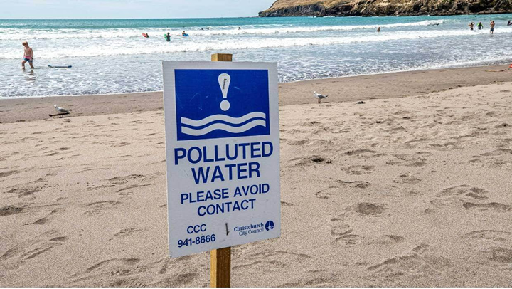
In Canterbury, the Lyttelton Harbour Company conducts dredge dumping for maintenance near the shore. This could alter both water quality and bathymetry, which in turn would alter the surf breaks located there. Following an appeal by the Surfbreak Protection Society, the resource authorization for the dumping of maintenance dredges included a condition that the local community participate by sharing information on wave quality, monitoring and determining, if necessary, the need for management measures. In the image, Taylors Mistake beach appears closed after being declared unsafe due to a sewage spill. Photo: Stacy Squires.
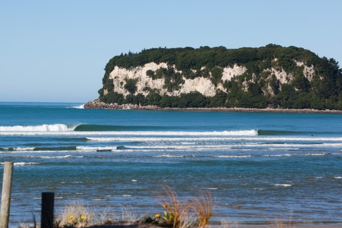
Whangamata Bar is one of New Zealand's nationally significant surf breaks. Currently, there is debate as to whether the wave quality is compromised by a dredging program for the harbor jetty entrance channel, which would affect bathymetry and tidal movements. Photo: Jwan Milek.

In 2018, an earthquake in Kaikōura, a town near the famous Mangamaunu Nationally Significant Break, caused developers to want to build a bike path that, because it was under the Emergency Act, could omit the respective environmental impact assessment. Surf break Protection Society filed a lawsuit and took the case to the Supreme Court of New Zealand, successfully preventing the construction of the project, as it could affect the wave and historical and sacred sites for the indigenous population. Photo: Warren Hawke.
3/
PUBLIC ACCESS AND COASTAL-MARINE POLLUTION
The Resource Management Act of 1991 provides the legal framework for the management of water pollution and the protection of marine-coastal ecosystems. In addition, there are other laws and regulations that address marine pollution and environmental protection in New Zealand. Some of these are outlined below:
Water Pollution Act. This act regulates water pollution and sets standards for water quality in rivers, lakes and other water bodies.
Marine Mammals Protection Act. This act protects marine mammals, such as dolphins and whales, and establishes restrictions on interaction with them.
Marine Environment Protection Act. This act aims to protect the marine environment and coastal biodiversity by creating marine protected areas and regulating human activities in those areas.
Environment Protection Authority Act. This law establishes an Environment Protection Authority responsible for regulating and controlling activities that could have a significant impact on the environment.
The National Coastal Policy contains provisions related to pollution, within the framework of its Objective 1 and Policies 21 and 23. Another noteworthy regulation is the Waste Minimization Act 2008, which encourages the reduction of the amount of waste generated in New Zealand. The aim is to reduce the environmental damage caused by waste and to provide economic, social and cultural benefits to New Zealand.
Finally, New Zealand National Coastal Policy contains two objectives (4 and 6) and three policies (18, 19 and 20) related to public access to surf break areas.